What a weather. Anyone who has spent this July in the Alps can tell you a thing or two about it: It rains, rains, rains. Instead of hiking and climbing mountains every day, I end up spending most of my time waiting for better weather. And the weather forecast turns out to be completely useless: When my phone gets a “severe thunderstorm” warning, the sun is shining. When it’s supposed to be sunny, it’s pouring with rain. And when I drive hundreds of kilometres because the weather is supposed to be better there, the bad weather front makes it all the way to catch me…
I really wanted to go to the Eastern Alps this summer because I have really neglected them so far. I’m currently working on the 2nd edition of my book Bewegte Bergwelt (Update: english edition The Formation of Mountains) and I wanted to take some photos for it. I actually got these, at least more or less.
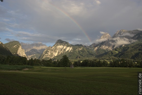
Dachstein and Gesäuse
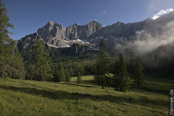
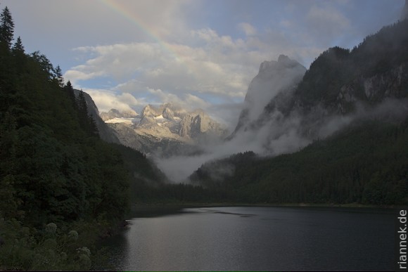
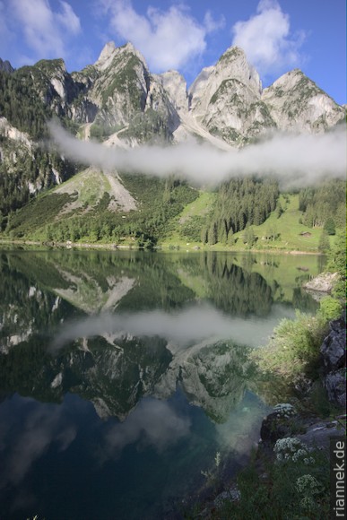
I have my first rain break early in the morning below the south face of the Dachstein. While it pours, I drive around the Dachstein massif to Lake Gosau and hike dripping wet to the upper lake and back. It only breaks up again around sunset … and again at sunrise. The clouds passing between the jagged limestone peaks above the lake look pretty good and compensate a little for the missed summit.
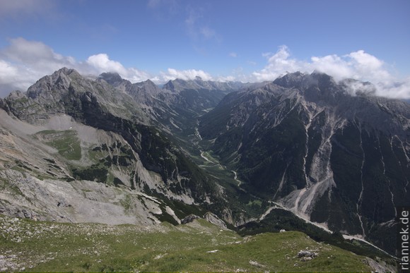
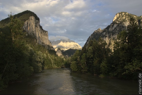
Now I drive far east to the Gesäuse, because the weather there is supposed to stay quite good — but in the end it rains there too. The Enns forces its way between the towering limestone mountains Hochtor and Buchstein. The “Gesäuse entrance” at Weng is particularly beautiful, the sudden transition from wide valley to narrow gorge.
From the other end of the gorge it is only a short detour to Erzberg near Eisenerz. A large metasomatic siderite deposit is mined here (cf. my book The World of Mineral Deposits). I take the opportunity to take a look (from the outside) at the large open-cast mine.
Torrential rain follows over the next few days. In Berchtesgaden a road is partially washed away, mudslides go off everywhere and paths become impassable. I spend as much time as possible underground. The salt mine in Hallstatt is disappointing, the tour goes from one light show to the next and I feel more like in an amusement park than in a mine.
On the other hand, the Eisriesenwelt near Werfen is really great. The entrance to this ice cave is high above the Salzach valley. I reach it by a combination of shuttle bus, cable car and short walk. As soon as the door is opened, a strong icy wind blows out of the cave. Inside, a sloping shaft leads upwards and the first ice formations come into view. At the top, you pass through several small halls filled with “stalactites” and “stalactmites” of bluish ice. And what’s particularly great about this is that the cave is not illuminated with spotlights. We get a few carbide lamps, every now and then a magnesium rod is burnt, that’s all — and that makes for a particularly beautiful atmosphere.
High Tauern
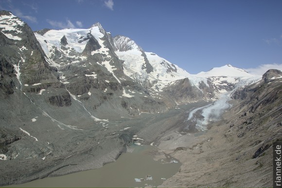
On the first reasonably good day, I drive early in the morning via the Großglockner-Hochalpenstraße to the Kaiser-Franz-Josephs-Höhe. Actually I want to climb the Fuscherkarkopf, but unfortunately the access path is closed: A mudflow has come down here too. Instead I just take a walk to the ice cave at the front of the Pasterze glacier. In the morning, some clouds are already gathering on the peaks, while I head for viewpoints like Hochtor and Edelweißspitze along the road. Actually, I later wanted to go to the Kürsingerhütte for a good view of the Großvenediger, but a mudslide has made this hut virtually inaccessible for some time.
For my only real mountain tour, I catch the only day with perfect weather: The Watzmann traverse is worth its own article.
Mainzer Höhenweg (Ötztal Alps)
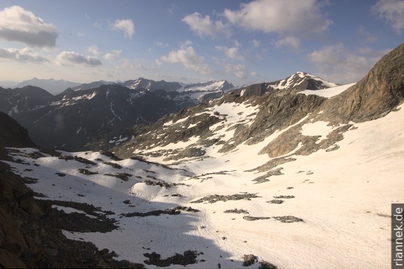
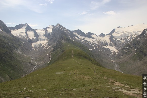
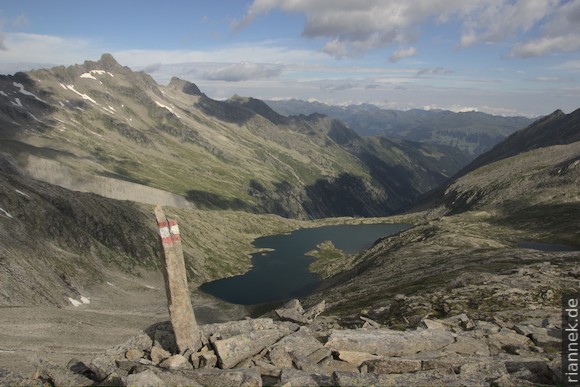
Then I drive to the Ötztal Alps, up the Pitztal, and climb to the small, cosy Rüsselsheimer Hut. The next day, in good weather, I hike via the Mainzer Höhenweg to the Braunschweiger Hütte: 10 hours through alpine terrain. At the beginning, below the peaks, it goes from one cirque to the next: I trudge over glacier remnants, scramble through gullies and over rock ledges. In not so old photos the glaciers still have crevasses, but not much is left. Now unfortunately they look like snowfields!
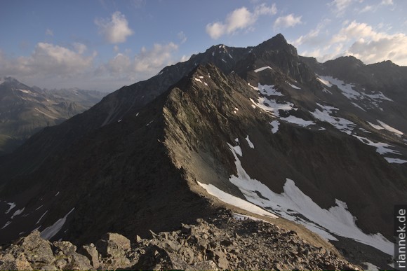
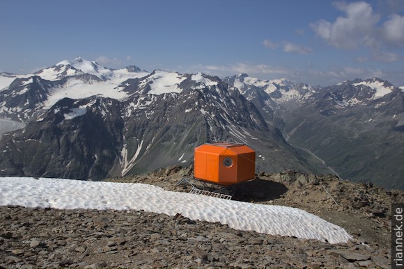
Finally I reach the ridge and follow it up to the Wassertalkogel (3252 m). At the summit there is a small orange-red bivouac box that looks like a mixture of pop art and a lunar lander. The view is great, especially of Wildspitze, Watzespitze and Verpeilspitze.
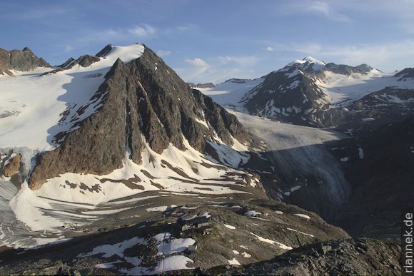
I continue over the ridge and several smaller peaks until I reach the very beautifully situated hut Braunschweiger Hütte. The glaciers in the background have lost quite a lot of surface area in recent decades!
The Braunschweiger Hütte is full of hikers who reach their highest point here during the Alpine crossing on the E5 long-distance track from Oberstdorf to Meran. I notice that they have all travelled up the entire Pitztal valley by bus. How disappointing. Quite apart from the fact that Merano is still in the middle of the Alps and you could continue easily along the spectacular Brenta!
Garnets of Granatenwand
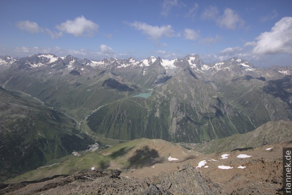
I follow the E5 route down to my car, drive down the valley and up the Ötztal again. From Obergurgl I take the cable car up to the Hohe Mut, a magnificent vantage point. On both sides of the grassy ridge, two picture-book U-shaped valleys run parallel to each other, with glaciated mountains behind them. I follow the ridge for a bit and then descend into the left valley. The mountain on the other side is rightly called Granatenkogel (“Garnet Mountain”); numerous large garnet crystals can already be found in the ground moraine on the valley floor. At the front of the glacier, I climb up the unpleasantly steep and rather slippery lateral moraine to the famous “Granatenwand” site. There are numerous garnets in the debris on the slope, which I only have to pick up. Unfortunately, a thunderstorm comes up and I don’t have time to look at the actual rock. In the pouring rain I crawl back down the moraine…
Eibsee and Zugspitze
My next destination is the Zugspitze. At sunrise I arrive at the Eibsee, the lake below this mountain and just see the mountain disappear in clouds. I walk along the northern shore, through hilly blocky terrain, past small pools, to the best vantage point. Here you can see across the islets to the Zugspitze. But I have to wait quite a long time for it to appear between the clouds.
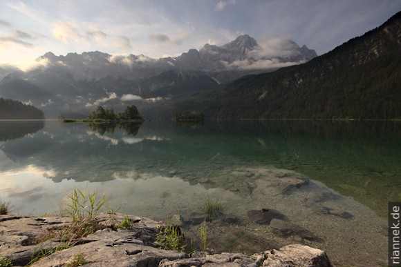
The islands, bays and pools date back to a huge landslide that happend sometime in the Bronze Age. Part of the Zugspitze rushed into the lake, the scar is the V-shaped “Bayrisches Schneekar”, seen from Lake Eibsee on the left below the main peak. The landslide mass literally slithered through the lake and surfed up the smaller mountain on the opposite side.
Later I take the cable car up, but then get stuck in clouds again. The view of the “glacier” is still clear, but not very nice with all the ski facilities.
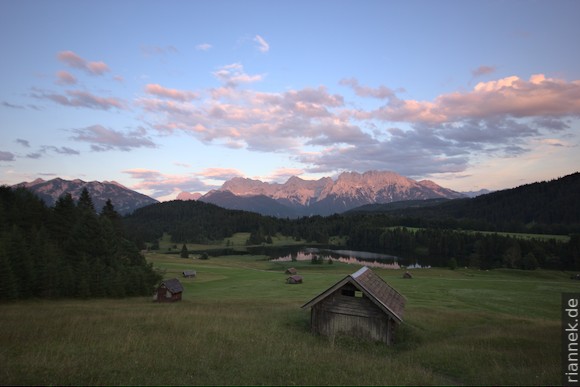
Shortly before sunrise it clears again. I am standing at Lake Gerold: in the foreground some haystacks, behind the lake the Karwendel glows red. The next morning it pours again and I change my plans once again.
Zillertal and Zittauer Hütte
As a substitute for the still unreachable Kürsingerhütte, I want to go to the Zittauer Hütte, which is located in the far west of the Hohe Tauern. While I’m driving up the Zillertal, the weather is suddenly good again and I spontaneously squeeze in a little hike: From Mayrhofen up with the Ahornbahn and via Edelhütte to the Ahornspitze (2973 m). However, the higher mountains are still in the clouds.
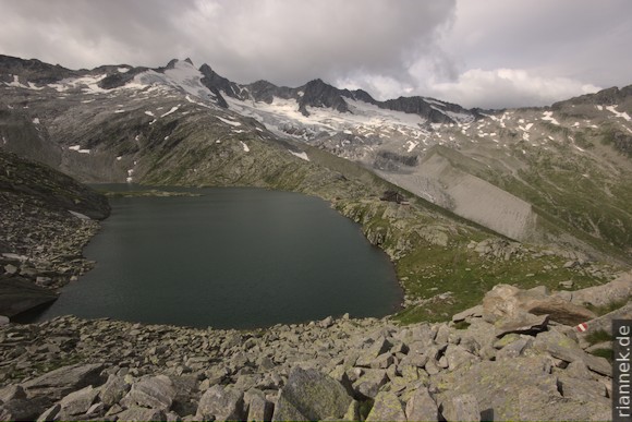
The next day I turn off from the Gerlos Pass to a carpark at Hotel Finkau and hike up the valley to the Zittauer Hütte. First I go through a short gorge, later over a steep scarp and along the moraine. The hut is beautifully situated on the Lower Gerlossee, with Gabler, Reichenspitze and Wildgerlosspitze towering above. I climb to the Obere Gerlossee and then head for the Wildkarspitze (3073 m) without a trail. First I go through a steep couloir, then I climb up and down the ridge in the 2nd degree to the summit cross. Apart from a single cairn, the route is not marked and there are no fixed ropes etc.
The next morning I hike to the Rosskopf, a popular lookout peak. However, the weather again leaves something to be desired and I am back at the car by midday.
Mittenwalder Klettersteig
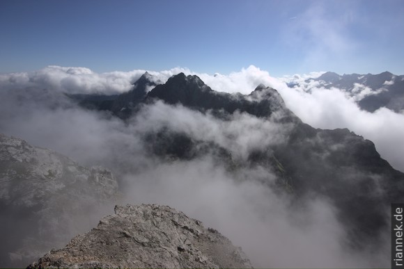
For my last tour (inspired by the weather forecast) I take the route from 2 days ago back to the Karwendel. In the morning I took the first cable car up from Mittenwald, then warmed up on a 10-minute via ferrata to the Westliche Karwendelspitze. The highest peaks of the mountain range just peek out of the billowing clouds, which looks terrific. Back to the Karwendel pit at the mountain station (this large hollow in the ridge is a sinkhole), I follow the ridge on the other side via the Mittenwald via ferrata. It’s very scenic (though the clouds might make it even more exciting), otherwise fairly easy and not exactly very exposed. The further I get, the greener the slopes become and the more the clouds dissipate. At the other end, after a detour to the Brunnsteinspitze, I descend back to the valley via the Brunnsteinhütte.