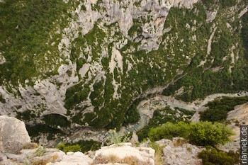
The “Grand Canyon” of the Verdon may not be the deepest gorge in Europe (the Tara Gorge in the Balkans is deeper), but it is without question one of the most impressive. The Gorges du Verdon in Provence cut up to 700 m into a high plateau on the margin of the Alps. The high rock faces on both sides, limestones from the Jurassic and the Cretaceous, are popular among climbers. Hikers who want to descend into the gorge, however, are limited to a single route, the Sentier Martel, which leads in about 6 hours from the Chalet de la Maline along the gorge to the Pointe Sublime.
There is a bus between the starting point and the end point of the hike several times a day during the season, and there are also taxis and hitchhiking would be an option. We park at Pointe Sublime in the morning and happen to just catch a bus to Chalet de la Maline. The small hut is located on the highly recommended panoramic road Route des Crêtes (see below), at the southern end of the deepest section of the gorge. From here, the relatively well-maintained path descends almost to the river and then follows it upstream. It goes up and down constantly, sometimes quite steeply, which makes the sweat pour. In summer it is very hot here, without a breath of wind. One major loop of the river in particular is “shortened” via a high vantage point, and on the other side it goes down again via a steep iron staircase through the Brèche d’Imbert crevice. A good place to rest by the river with a view is the Plage des Fères. After that, the deepest part of the gorge actually begins, but it doesn’t look as spectacular from below as it does from above, as here the rock walls don’t reach very far down and instead we cross over slopes overgrown with bushes. Only in the upper part, in the Trescaire area, does the high rock face Barre de l’Escalès reach down to us and it becomes narrower and impressive again. The last section, the Couloir Samson, is not quite as deep, but particularly narrow. Here the trail leads through two tunnels that were once built for a hydroelectric power station. The second is 700 m long and pitch dark, so a torch is absolutely necessary. A short branch in the tunnel leads to the Grotte Baume aux Pigeons, a scour in the narrow gorge with a fascinating view. Shortly after the tunnel exit, we reach a car park at the end of a short spur road, vertically above it is the viewpoint Pointe Sublime. On foot, a steep path leads in about half an hour to the upper car park, which is at the Pointe Sublime hut on the main road.
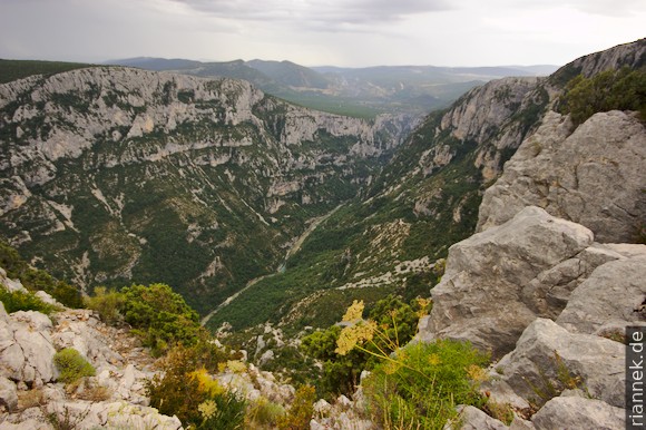
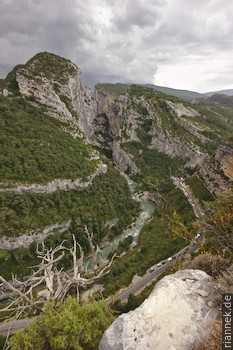
The next day, we do a loop of the panoramic Route des Crêtes, which is not to be missed. The start and end points of the road are at the village of la-Palud-Sur-Verdon, and the road can only be driven clockwise as it is a one-way road (except for the last stretch between Chalet de la Maline and the village). It goes from one viewpoint to the next and it is really worth jumping out of the car every few bends. The first viewpoint is Belvédère de Trescaire: on the left the narrow Couloir Samson, down a deep view into a particularly narrow and deep part of the gorge, on the right the north end of the high rock face Barre de l’Escalès. The other end of this rock face is about 2 km away at Belvédère de la Dent d’Aire, where climbers are often seen. The view from here to the south is also impressive; this section is slightly wider but particularly deep. A few bends further on from the Belvédère du Tilleul, the deepest part of the gorge can be seen from the other side. From here, the road winds down to the Chalet de la Maline, following the gorge for many more bends and viewpoints and finally returning to the start.
Read on
The Formation of Mountains
Roussillon und Gordes
Calenques bei Cassis