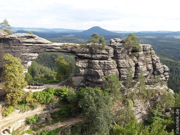
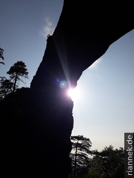
The impressive Prebisch Gate near Hřensko is by far the largest rock gate in the Elbe Sandstone Mountains and the largest in Europe, it can almost compete with the famous rock arches on the Colorado Plateau in the USA (e.g. Arches National Park in Utah).
Until now, I was mainly familiar with Saxon Switzerland on the other side of the border, with its table mountains and sandstone towers, with the alternation of wide views and narrow gorges, and there too there are (smaller) rock gates such as the so-called Kuhstall. Bohemian Switzerland, which is directly adjacent in the Czech Republic, is of course very similar, but the Prebisch Gate stands out and it is one of the highlights of the whole region, along with Bastei, Königsstein and Schrammsteinaussicht. From the vantage points above the rock gate, you can see also see a typical “rock town” with strongly fissured rocks and rock towers on the other side.
The sandstone, with a total thickness of over 500 m in places, was deposited near the coast in the Late Cretaceous in the sea, which reached a particular high sea level at that time (cf. The Formation of Mountains). This basin was much larger than today’s Elbe Sandstone Mountains and reached, for example, as far as the Bohemian Paradise further to the east. Towards the end of the Cretaceous, the sea retreated and an overthrust along the Lusatian Fault led to a first uplift.
The rock formations were formed by erosion in several phases, whereby the network of fissures played an important role. First of all, in the Tertiary, in a hot and humid climate, there was strong chemical weathering in the subsoil, which attacked the cement between the sand grains, especially along the fissures. During this time, further tectonic movements began as a remote effect of the Alps: Europe reacted to the Alpine mountain building with evasive movements of smaller crustal blocks and an extension roughly in an east-west direction. Immediately to the south-east of the Elbe Sandstone Mountains, this caused the Eger Graben to subside, and on its north-western side the Ore Mountains rose. The Elbe Sandstone Mountains are located near the end of the graben, they were also uplifted — especially in the southwest — and tilted in several phases. The formation of the rift system was also accompanied by volcanism in the Elbe Sandstone Mountains. Many volcanoes are easily recognisable today by their dome shape, such as Großer Winterberg (about 2 km northwest of the Prebisch Gate, across the border) and Růžovský vrch (Rose Mountain, about 4 km southeast of the Prebisch Gate and well visible from the lookout points).
The Elbe and its tributaries cut into the uplifting block and erosion changed fundamentally: the already loose material along the crevasses was quickly washed out. During the ice ages, there was severe erosion due to frost blasting. Since then, weathering has slowed down, but water, frost and salt (through capillary rising water) still change the shape of the rocks. The former tableland has dissolved into a landscape of deep gorges, gently rolling plateaus and even higher mesas.
The first step in the formation of a rock gate is a fin of sandstone that remained between two fissures widened by erosion. Now the process known as exfoliation is likely to play the most important role. This refers to the detachment of shell-like rock slabs, especially in granite, which is triggered by pressure relief (when the overlying rock is removed). Similarly, when pressure is relieved on a sandstone rock face, large slabs can flake off. With luck, this will create a window in the sandstone wall. More blocks collapse until either the statics are just right, as with a bridge, or (more likely) the entire structure has collapsed.
The Prebisch Gate can only be reached on foot, either from Hřensko (the border village on the Elbe) or from Mezni Louka (little more than a hotel and campsite on the road towards Jetřichovice). As the Edmundsklamm (Edmund’s Gorge) runs between the two places on the other side of the road, a circular route (approx. 5 h) is a good idea. Part of the Edmundsklamm gorge is dammed up and hikers are transported on a punt for a few euros or crowns. On the way, you also pass an artificial waterfall that is activated by a ripcord, and similar grandiose highlights that are fortunately commented on with much irony by the captains.
Literature
Migon (2010) Geomorphical Landscapes of the World. Springer, Heidelberg.
Wagenbreth, Steiner (2015) Geologische Streifzüge: Landschaft und Erdgeschichte zwischen Kap Arkona und Fichtelberg. 4. Aufl., Springer, Heidelberg.
Geologische Karte der Nationalparkregion Sächsische Schweiz (1993)
Neukirchen (2022) The Formation of Mountains. Springer, Berlin.
Read on
The Formation of Mountains
Basalt columns at Panská skála
Trosky, a volcano in the Bohemian Paradise
Autumn in Saxon Switzerland
Hiking the Malerweg through Saxon Switzerland