The miners in the Upper Harz had a problem from the 16th century onwards. The deeper their pits became, the harder it was to get the water and ores out. Miners climbing up ladders with filled buckets were no longer enough. But to drive pumps, a water wheel and a stream were needed. The productive mines, especially in Clausthal and Zellerfeld, were located high up, the Upper Harz is a kind of high plateau. It sounds paradoxical: in order to lift the water out of the pits, more and more water had to be brought to the shafts in a system of channels and ponds.
▸ The World of Mineral Deposits
▸ Von der Kupfersteinzeit zu den Seltenen Erden (only in German)
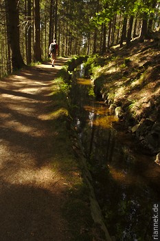
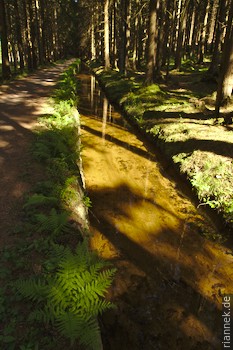
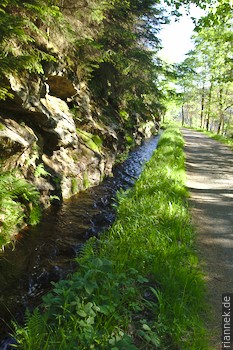
Within 300 years, channels with a total length of 500 km were dug to collect water and bring it to the mines, and 143 ponds were dammed to store the water for dry times (not all were active at the same time). Part of it is still preserved and since a path was also built next to each ditch, this cultural monument can be nicely explored by food. Some trails are marked as edicational trail, between short walks and half-day hikes, everything is possible.
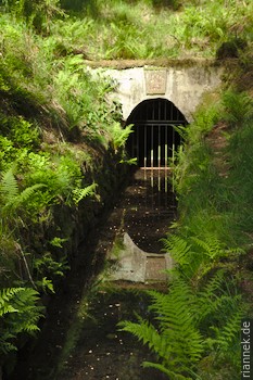
“Keep the waters high” was the motto. The channels run with minimal inclination and almost follow the contour lines. And sometimes several parallel channesl were laid out at short intervals, the water from the upper one could thus drive one more water wheel, while the lower one could supply water from a greater distance. The ponds were usually arranged as a cascade on top of each other, the water from the uppermost pond flowed over several water wheels and through several more ponds before it reached the deepest point of the system. When at some point a water tunnel had been constructed from the valley to the mine, it was even possible to install water wheels underground and use them to drive the deepest pumps.
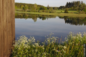
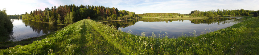
A kind of “Best Of” is the combination of the rather short trails “Hutthaler Widerwaage” and “Hirschler / Pfauenteiche”. The three Pfauenteiche (“peacock ponds”) and the Hirschler pond directly above them are a cascade on the eastern outskirts of Clausthal, close to two particularly productive mines. The large and elevated Hirschler Teich was particularly important because its water could be used first for the Carolina mine and then for the Dorothea mine. From the upper Pfauenteich, the water still made it to the Dorothea pit, while the middle and lower ponds were already so low that the power had to be transferred from the water wheel to the pit with a “Stangenkunst” (a wooden linkage).
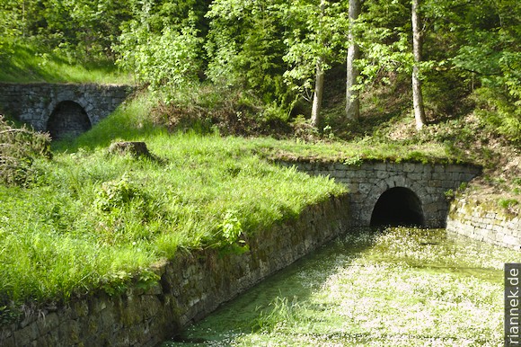
So as much water as possible had to be supplied to the Hirschler pond. For this purpose, the Huttaler Widerwaage was built in the 18th century. It is a small reservoir connected by a horizontal gallery to the Hirschler Pond on the other side of the watershed. In addition, a horizontal channel follows the slope to the Lower Hutthal Pond (which is no longer filled with water today), which thus effectively became a side basin of the Hirschler Pond. At that time, one was not at all sure whether the water would flow at all without a slope, but it worked: at low water, water from the neighbouring valley could now flow into the Hirschler Pond, and at high water, excess water could flow in the other direction and be stored in the Hutthal. The hiking trail leads over the dam of this pond, which was also an aqueduct, the channel leads directly over the top of the dam.
Soon you reach the Schwarzenberg watercourse, a gallery that leads back to the other side of the watershed — via this shortcut, water collected on the other side could still reach the Hirschler pond. The trail continues to the Polsterberg Hubhaus, now a restaurant. In former times, water was pumped here from a deeper channel into a higher channel. The Jägersbleeker Pond follows and finally the Hirschler Pond is reached again.
For a longer hike, I recommend the Dammgraben channel above Altenau, which collected water from the Brocken area and brought it towards Clausthal. The path is very pretty with many curves along the slope through the forest, always with the rippling water next to the path. Unfortunately, after 10.5 km you also have to return (and the easiest way to do so is along the same path).
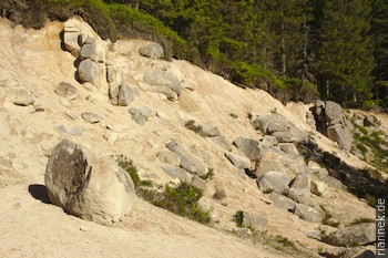
The Rehberger Graben (which can be combined with a more direct return route to make a 15 km loop) is very interesting as well. It brought water from the Oderteich — a veritable reservoir, over whose dam the federal road 242 runs — to the mines in Sankt Andreasberg. Here the channel construction was particularly difficult because it partly went along a steep slope with rocks and boulders. Along the way, you pass an outcrop where granite has largely turned to sand due to severe chemical weathering, but individual “wool bags” and corestones (i.e. granite boulders) are still preserved. A particularly vivid example of how “wool bag weathering” works.
To see more than just forest and water, I visit the very impressive mineral collection of the TU Clausthal, the mining museum Oberharzer Bergwerksmuseum in Zellerfeld and Samson Mine in Sankt Andreasberg.