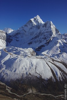
In the Khumbu Himal, there are a few other very high and impressive mountains besides Everest, and to be honest, some of them put Everest in the shade when it comes to beauty. Names of giants like Lhotse, Nuptse, Makalu or Cho Oyu are familiar to many, as are those of beauties like Ama Dablam, Cholatse or Pumori. Other names, such as Kangtega or Thamserku, most will only get to know on the way. Nevertheless, Everest remains the magical goal, even if it is not the summit for us trekkers. But it is the other mountains that make a trek in this region an unforgettable experience.
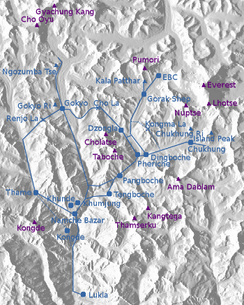
Most people simply hike up the valley on the well-built “Yak Highway” to Everest Base Camp. Since Everest is not visible at all from there, they climb the small lookout peak Kala Patthar (5550 m) and then go back the same way. This takes about 2 weeks (because of acclimatisation, the stages are quite short) and the route is rich in views. Nevertheless, you should make more of it and explore the other valleys as well. The valleys of the Khumbu are fanned out like the fingers of a hand and connected by high passes that are counted among the best viewpoints in the Himalayas.
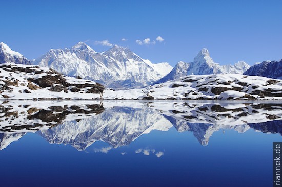
Not far from Everest Base Camp, the Cho La Pass (5420 m) leads over to Gokyo. This is the second most popular trekking destination in the region: with Gokyo Ri (5360 m) there is a small peak with great views, plus a huge valley glacier flowing down from Cho Oyu, whose lateral moraine dams up a series of mountain lakes. Another pass, the Renjo La (5360 m), leads from here to the valley of Thame. From the valley with the Everest Base Camp, a third pass, the Kongma La (5535 m), leads in the other direction into the valley of Chhukhung. Here the lookout mountain Chhukhung Ri (5550 m) awaits.
It all adds up to a beautiful loop that takes just under three weeks and is certainly one of the most impressive treks in the world, treating you to an abundance of changing views. It is usually called the “Three Passes Trek” or “Everest High Passes” or something similar. A tent is not really necessary, there are “teahouses” (hostels) everywhere, but with a tent you can still make a few worthwhile detours. This year there was an unusual amount of snow and I was glad that I could still do almost everything according to plan.
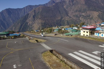
The adventure already starts with the flight to Lukla (you could also take the bus to Jiri and hike from there to Lukla in four hard days, but only very few people do that). Small propeller planes shuttle the short distance between Kathmandu and Lukla in good weather. Through the dirty window, first the Langtang Himal can be seen, then Gauri Shankar looms prominently and finally the great ones of the Khumbu come into view. Then we plunged into the cloud cover. Now and then steep mountain slopes and deep gorges could be seen through holes in the clouds. Suddenly the short airstrip appeared directly in front of us, leading up a not-so-steep slope. Lukla is considered the most dangerous airfield in the world. I didn’t think the landing was that bad, but the idea of building an airport on this spot is quite daring.
While I was waiting for my luggage and then found out that my petrol stove had not survived the flight or rather the harsh treatment of the luggage on the ground (I managed to fix it with a tube of Super Glue in a makeshift way) and my pot was completely dented, the clouds condensed into a dense, dark grey mass. Two more planes landed after me, and then all flights were cancelled for the next two days. By the way, this happens quite regularly (the best chances are early in the morning), so you should always plan a few extra days as a buffer!
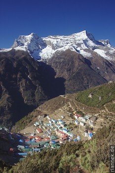
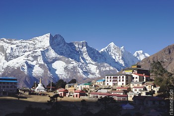
That same day, I hiked to Namche Bazaar through the green valley from village to village. The cloud cover was too depressing to linger on the way. Namche Bazaar, with its horseshoe-shaped arrangement of houses, fills a bowl-shaped valley high above the confluence of the Bhote Koshi Nadi and Dudh Koshi Nadi rivers. It is considered a typical Sherpa village, but has grown so much in the last decades that I don’t think it is too typical.
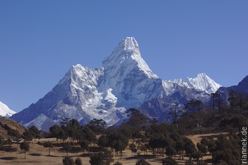
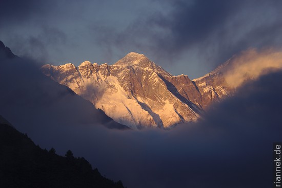
Here, a walk to the villages of Khunde and Khumjung is worthwhile for acclimatisation, with great views of Ama Dablam, Thamserku, Everest and Lhotse. The charming thing is the vegetation in the foreground, still quite different from the barren white-brown mountain world you will be immersed in over the next few days.
From Namche, the trail leads into the valley of Thame, but I turned off just before this village and crossed back on the other side of the valley to reach the Kongde Hotel. The path turned out to be more strenuous than expected, it goes up and down quite a bit and on top of that, the steep staircase leading out of a shady gorge was covered with ice: a tricky affair even with the fixed rope. The hotel is quite expensive, but I had my tent with me and the climb is worth it for the panorama, especially if you climb up to the small rocky hump a little above or to the cirque lake nearby.
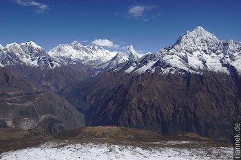
In Thame, a monastery can be visited, above it the wall of Kongde and Tyangmoche. Down the valley, Kangtega, Thamserku and Kusum Kanguru are clearly visible. The trail continues up the valley to Lumde. Apart from the view back, there is little of the really high mountains to be seen here, the wide brown valley is bordered on both sides by dark rocky peaks. Lumde is at an altitude of 4370 m, it will take some time until I am at such a low altitude again … Here, up the valley, a few big mountains are in sight, next to them a high pass leads over to Tibet. To reach my first pass, however, I turn right, up the steep mountain slope from Lumde. By the light of the headlamp, I climbed up to a hill and enjoyed the sunrise freezing. But it would be some time before I got the first warming rays of sun myself. The last stretch to the pass I was as slow as a snail, at this altitude there is only half as much oxygen as at sea level. Finally I reached the Renjo La pass and the view opened up to Everest, Nuptse and Lhotse, Makalu, Cholatse and Taboche, with the turquoise lake of Gokyo and the Ngozumpa glacier in front. In the other direction, some mountains of the Rowaling Himal can be seen. Truly an impressive viewpoint.
Quickly I was down in Gokyo, once a summer pasture and now a collection of hostels, nicely situated on a turquoise lake. My first meal here was inedible, the noodles tasted of kerosene. I only ate two forks and then immediately moved to another hostel, for two days I had to regurgitate regularly, the taste of kerosene coming back into my mouth each time. My new hostel had better food and I had a room with big windows in two directions. However, this turned out to be a disadvantage, as the single glazing gave me nights with below -10 °C in the room. Fully dressed with fleece and down jacket, trousers and long pants, wrapped in a sleeping bag, with a blanket over it: I was warm that way, but I still had to breathe and the freezing cold air hurt my lungs. No wonder I caught a severe cold. But that was part of being here: Almost every night my cough was answered by others coughing. The cold also made me photograph far fewer sunsets or sunrises than I had expected. One prefers to sit next to the warm cast-iron stove with yak dung glowing away. By the way, the air is so dry that a distinct red colour is rarely visible anyway; the rising sun appears in bright and white light.
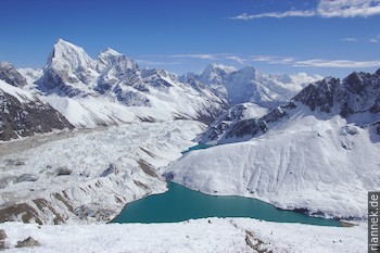
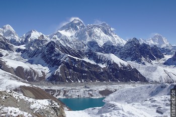
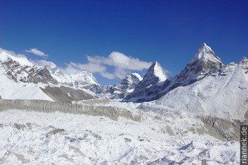
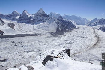
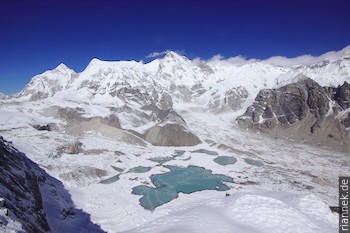
The next day I was anything but fit and trudged slowly up Gokyo Ri. The view from the top is similar to that from Renjo La, with the Ngozumpa Glacier and Cholatse more visible, while I found Everest better from Renjo La. After another cold night, I hiked up to the other lakes. Just before the 5th lake (Gokyo itself is the third, counting from the lowest one), the tracks scattered in the snow and I had to struggle laboriously through the snow crust. From the moraine you have one of the most beautiful views of Everest without a sporty climb (if it weren’t for the snow), thanks to a valley with a glacier arranged at the right angle.
I tried to hike up to the sixth lake (actually several lakes) at Cho Oyo Basecamp, but the snow got worse and worse. A few hundred metres from the goal I sank to my belly in snow and I had to give up. Strangely, I had met a Korean who claimed he had been there, but I couldn’t make out his trail anywhere. He had also said he had tried Ngozumpa Tse (5553 m), a lesser-known lookout mountain between Lakes 5 and 6 (my Nepalese map has this name on the wrong mountain, besides, these maps are full of mistakes), but had given up because of the snow (whether on the right or wrong peak I don’t know).
I had also planned to climb this mountain, but really everyone I asked said it was impossible at the moment. Yet from a distance it looked as if most of the snow on the peak had already melted away. So I wanted to try anyway, after a night in the tent near the 5th lake. Shortly after sunset, the thermometer on my watch read -8 °C, and the night was correspondingly cold. The moisture in my breath caused ice crystals to grow on the tent walls, which triggered a heavy snow flurry in the tent for a few seconds every time I moved. The next morning my watch claimed an absurd +10 °C, with the display barely legible due to the battery weakened by the cold. Everything was frozen: water, sunscreen, toothpaste. Even the petrol stove could only be started after it had been allowed to snuggle in the sleeping bag for a while.
Climbing the peak was then easier than I thought. In fact, most of the route was more or less snow-free and I only had to blaze a trail on the summit ridge. Obviously, I was the first to stand up there this season and enjoyed the view of Cho Oyo, the sixth lakes, Gyachung Kang (at 7952 m the highest 7000 m peak in the world), the fifth lake, Everest and many other mountains.
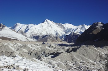
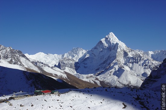
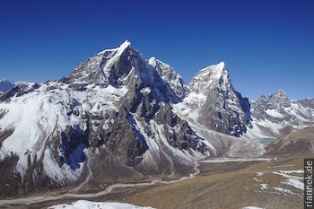
From Gokyo I had to cross the Ngozumpa Glacier, a steady up and down, always with great views of Cho Oyo. On the other side, I climbed up to Cho La Pass. From the pass itself you don’t have such a great view, but if you are interested in geology, you can see some impressive leucogranite dikes in the high-grade sillimanite gneiss. On the descent, the view opens up and Ama Dablam and the north face of Cholatse appear like two huge pyramids. Directly below Cholatse is Dzongla, the destination of this stage.
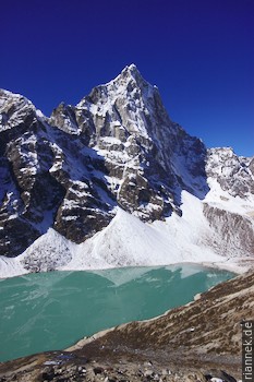
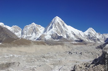
A little down the valley, I cross the slope above a pretty lake with Cholatse towering over it. A little later, I turn into the next valley and reach the Khumbu Glacier and the village of Lobuche. Pumori and Nuptse dominate the view here. Soon I reach Gorak Shep, from where Everest Base Camp can be reached as a half-day excursion. But first I climbed Kala Patthar in the afternoon.
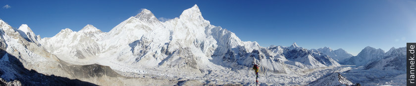
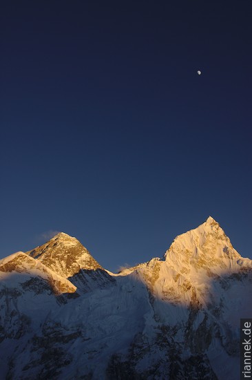
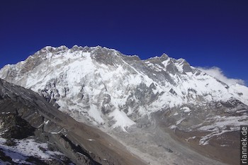
The famous lookout mountain above Gorak Shep is in reality just a mound of rubble at the foot of Pumori. Opposite it, like a pointed pyramid, Nuptse can be seen in profile, and to its left, half hidden by its own west shoulder, a huge dark pyramid, broad and mighty, its summit towering over Nuptse by a kilometre: Mount Everest. The Sherpa, Tibetans and Chinese call it Qomolangma (Chomolungma), for them it is the mother of the earth. The Nepalese then called it Sagamartha, Mother of the Universe. Although, to be honest, Everest looks more impressive from the other base camp in Tibet. Anyway, luckily it was almost windless and I could wait until sunset for the last red light to disappear from the top of Everest (I don’t understand why almost all the groups come up here at sunrise when everything is backlit).
Even though Everest itself is not visible from Everest Base Camp, the hike is worthwhile. The valley basin is very impressive even from this angle. I followed the access trail from the camp (where there were currently no tents, due to the snow this was not a viable season) to near the icy spikes of the Khumbu Icefall.
Back in Lobuche, I was concerned with the third pass, the Kongma La. It is faster to bypass this pass through the valley, but the view is the goal. Almost everyone told me the pass was closed because of the snow, but I’d heard of a group that had wended their way over the pass three days earlier, and I met three Sherpas in Lobuche who had just come over the pass. So I crossed the Khumbu Glacier in the morning without knowing the exact route, it took me two hours to search my way between ice hills and meltwater lakes. Then it was up a steep valley, luckily there really was a trail, and at noon I sat on the pass and looked across the frozen blue lakes to Makalu and Baruntse, with Nuptse and Lhotse to my left. At exactly the same time, three hikers came from the other direction, otherwise I didn’t meet any people until the evening in Chhukhung.
There, most people want to climb Island Peak (for which you need a permit). I was content with the Chhukhung Ri, on which one stands directly below the south face of Nuptse and Lhotse. On Nuptse, I was impressed by the leucogranite intrusion.
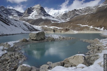
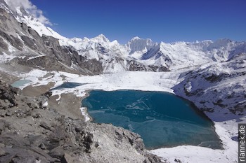
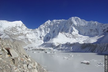
At Island Peak Basecamp I had a look at the lake Imja Tsho, which has only been formed in the last 50 years because the glacier has retreated rapidly.
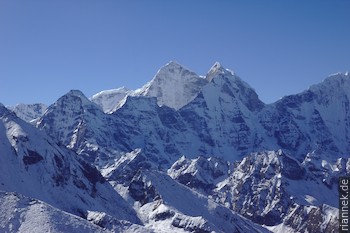
Down the valley, I stopped in Dingboche to climb Nangkar Tshang (5075 m), a last panoramic mountain. This time, Cholatse, Taboche, Ama Dablam and Kangtega are particularly impressive.
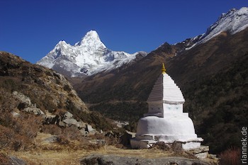
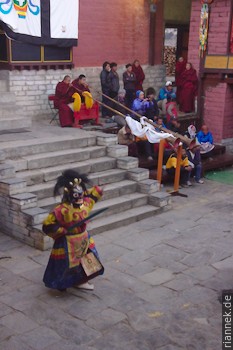
After that, I just had to walk down the Yak Highway: Via Pangboche (where a short detour to the monastery is worthwhile) I reached Tangboche Monastery through a low mountain forest, which is situated on an old terminal moraine with a great view. The most important monastery in the region unfortunately burnt down in 1989 and was then rebuilt. I arrived just in time for a festival, Mani Rimdu, which is celebrated with an endless dance performance in changing costumes. Even tourists were made fun of, one character danced with a huge cardboard camera. Apart from many Sherpas, there were also many tourists and the hostels were bursting, but luckily I had my tent.
From Namche I repeated the round to Khunde and Khumjung, this time with real mountains instead of mountains of clouds in the background. And at the hotel, a hot shower! The solar showers higher up might work in high season, but by the end of November it’s too cold. Imagine a draughty corrugated iron box with a sign saying “Hot Shower”, the concrete floor covered with a thick layer of ice, with a daily maximum temperature of maybe -5 °C. You don’t even want to try whether liquid water comes out of the tap.
In Lukla, the weather was perfect, but for a few hours there was not a single flight – bad weather in Kathmandu, that also happens. But after half a day’s delay, I arrived in the capital.
Update: Practical tips
Since I regularly get questions about this trek, here are a few tips for planning:
- For better acclimatisation, it is better to walk anti-clockwise. If you have been on another trek at a similar altitude immediately before, like me, you can walk clockwise.
- It is better to plan more days for acclimatisation than less. On this trek, these excursions are real highlights!
- Once the first pass is done, everything goes much faster. So don’t stress at the beginning, 3 weeks are enough including acclimatisation trips.
- For example, EBC and Kalar Patthar from Gorak Shep are only half days (if you are well acclimatised).
- From Gorak Shep to Dzongla is a short half day. From there, a very long day is possible over the pass to Gokyo, better to stay one night east of the glacier after the pass, you can still climb Gokyo Ri the next day.
- Fron Lumde (below Renjo La) you can walk to Lukla in 3 days.
- Take several spare batteries for the camera, there are only solar panels at the huts above Namche and this is not necessarily enough for all hikers.
- A tent is not necessary, there is plenty of accommodation. The only exception is Ngozumpa Tse (which is rarely climbed). If you want to climb it, you have to spend one night in a tent and carry it around for 3 weeks.
- As soon as the sun is gone it is very cold. A warm sleeping bag and warm clothes are of course necessary.
- As the Lukla-Kathmandu flights are often cancelled due to poor visibility, people regularly get stuck in Lukla for a few days. Plan your flight home accordingly.
Read on
Langtang-Trek and Gosainkund
Annapurna Cirquit
Trekking and Photography
The Formation of Mountains