Eiger, Mönch and Jungfrau, as magnificent as they are, are only the best-known mountains in the Bernese Oberland. In their neighbourhood there is a whole series of other fascinating peaks, all of which I had previously only known from passing by or from afar. Reason enough to hike along the foot of this area for five days. As a route I choose about half of the “Bärentrek” (with small deviations), namely from Kandersteg via Oeschinensee, Blümlisalphütte, Sefinafurgga to Mürren; by train up the other side of the valley to Kleine Scheidegg and from there on foot via the Eiger trek and on to Grindelwald. In addition, I choose the panorama trail above Grindelwald from First to Schynige Platte.
The best time for this beautiful route is July to September. In August, of course, the mountains often disappear in clouds in the afternoon, you may have to reckon with summer thunderstorms and you won’t be able to photograph the north faces in the best light (evening sun). You can stay overnight in mountain huts or hotels with mattress dormitories. What I shorten with mountain railways, you could of course also walk, but…
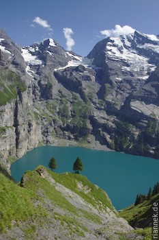
Many people know Kandersteg from the car loading point at the Lötschberg tunnel (easily reached by train). From here you follow the signs to turquoise-green Lake Oeschinen, which lies picturesquely below the rock faces of Blümlisalp and Doldenhorn. Up to here it is more of a walk, now it is really uphill to the Blümlisalp hut. You should definitely make a detour from the Oberbärgli alp to the west on the slope-parallel path, the views of the lake are magnificent. As you continue to climb to the hut, more and more of the heavily glaciated north-west side of Blümlisalp comes into view. Arriving at the hut, you have already climbed 1600 metres, quite respectable for the first day. For an even better view of the mountain, you can climb a little further.
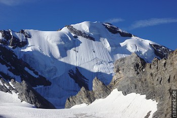
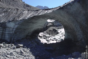
The next morning I descend into the Kiental. Almost 1000 m below, you can either descend (following the Bärentrek) another 400 m to Griesalp, from where you can tackle the next pass, the Sefinafurgga, or you can branch off up the valley towards the Gspaltenhornhütte, from where there is also a trail leading to the pass. I decide on the second option, I don’t know which is more beautiful and which is more strenuous. In any case, I come across several large ice gates at the front of the Gamchi Glacier, left behind by the melting ice and with streams flowing through them. Meltwater drips continuously from the gates and boulders roll down again and again. Here you can really watch the glacier melt, it won’t be long before the ice is gone. To cross the small gorge in the glacier remnant, you go over an aluminium ladder. On the other side you climb up again. Shortly before the hut, the path branches off to the pass, and most of the altitude metres have already been covered. From the pass you theoretically have a good view of Eiger, Mönch and Jungfrau, but in my case they are shrouded in clouds. Now it is not far to the Rotstockhütte.
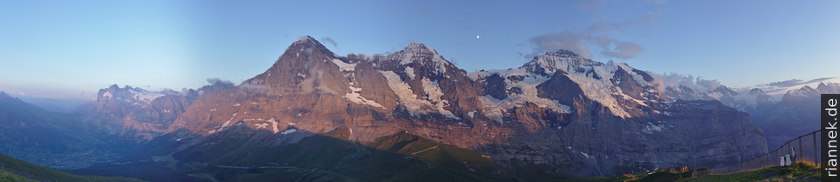
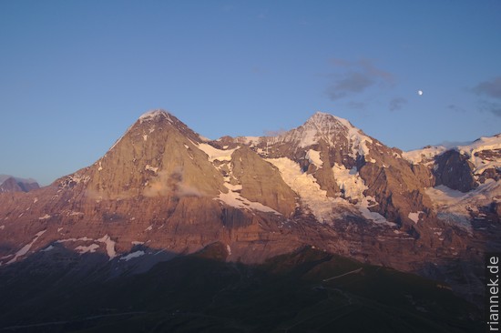
From there it is sometimes flat, sometimes descending to Mürren, often with great views of the high mountains on the other side of the valley, especially the Jungfrau, and back to the notorious north-east face of the Gspaltenhorn. Once in the village, I take the train (which goes flat to Grütschalp, from where you take the cable car down to Lauterbrunnen). If visibility is good, it is recommended to walk to Grütschalp or Lauterbrunnen instead. Then I lazily take the train up to Kleine Scheidegg and stand on the nearby summit of the Lauberhorn for sunset. The north face of the “triumvirate” of Eiger, Mönch and Jungfrau is within reach, and a little further on all the others like Wetterhorn, and Gspaltenhorn. Below, the wide valley of Grindwald and the narrow U-shaped valley of Lauterbrunnen.
The Bärentrek would be parallel to the cogwheel railway to Grindelwald from here. Instead, I climb the short distance to the Eigergletscher station and take the “Eiger Trek”, which leads directly below the Eiger north face. Occasional climbers can be seen (I don’t mean those on the small via ferrata on Rotstock, the rocky hump at the beginning of the trail) and I try to retrace the route of the first ascent with my eyes. As always, the wall doesn’t look that high when you’re standing directly under it, because it’s stretched out by the perspective and the height is hard to estimate. It is also strange to discover the windows of the Eigerwand railway station in the middle of the rock face. While most hikers now descend to Alpiglen and board the train there, I follow the signposts to the Gletscherschlucht (“glacier gorge”). The trail runs more or less parallel to the slope until it reaches the narrow valley, at the end of which the ice wall of the Fiescherhörner rises up. The Gletscherschlucht itself is the lowest part of the valley, at its entrance you have already reached the Grindelwald valley basin.
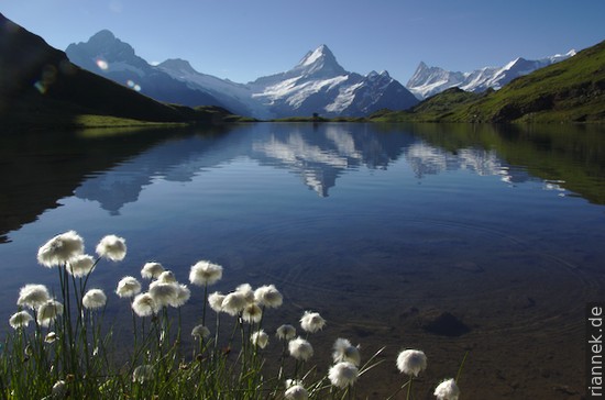
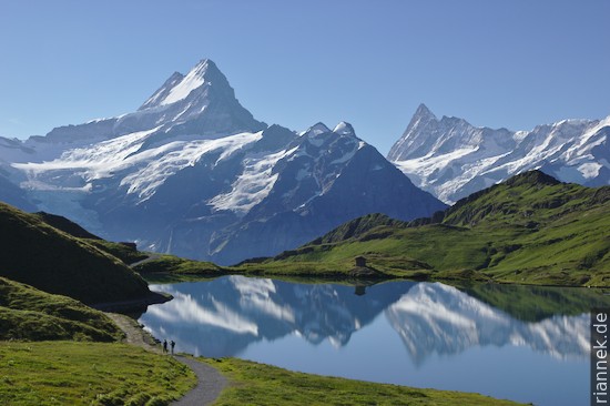
For one rainy day I stay in Grindelwald and regenerate my legs. Then comes the last stage, the panoramic route from First to Schynigen Platte. The day hike is part of the compulsory programme for Grindelwald tourists for a reason, which of course means that you are not entirely alone. Already during the cable car ride to First, the Schreckhorn comes into view from its most beautiful side, a beautiful mountain that on this trek one has hardly noticed so far (and directly behind it, as if an appendage, another 4000-metre peak, the Lauteraarhorn). To the left is the mighty north face of the Wetterhorn and on the other side the north face of the Eiger, which looks almost more interesting from First than from Kleine Scheidegg. While walking on the flat path to the Bachsee (or Bachalpsee), the Finsteraarhorn still comes into view, a pointed triangle and the highest peak to be seen on this hike. A picture of the Bachsee, in which the Wetterhorn, Schreckhorn and Finsteraarhorn are reflected, is something that every mountain lover has surely seen before.
Now I follow the wide path upwards and reach the Faulhorn, from this side nothing more than a grassy hump. So not exactly an alpine challenge, but with a beautiful view of quite a few 4000-metre peaks at the same time, which you can enjoy from the terrace of the restaurant during lunch. As you wind your way around a ridge as you continue, the high mountains temporarily disappear and then reappear from a different angle. Now it is not far to Schynigen Platte, where you can say goodbye to the mountain world with a classic view of the Eiger, Mönch and Jungfrau and take the cogwheel railway down to Wilderswil (near Interlaken).
Read on
The Formation of Mountains
Tour du Mont Blanc
Dolomites High Route n. 9
Traversing Corsica on the GR20
Trekking and Photography