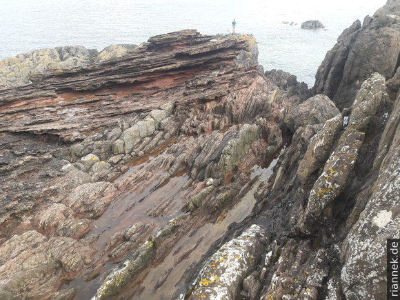
Probably the (historically) most important outcrop of geology is located on the coast about 40 miles east of Edinburgh. In 1788, at a time when geology did not yet exist as an independent science and hardly anyone doubted the common teaching that the earth — according to the creation story in the Bible — was only 6000 years old, James Hutton and his friends sailed along the coast in a boat. He was looking for the boundary between two very different rock units: Between the red sandstones (Upper Devonian) to the north and the greywackes and mudstones (Silurian) known further south in the hills of the Scottish Borders. He found them at Siccar Point, so beautifully exposed that you can literally see the geological processes over time. Today’s geology textbooks often show photos of the site.
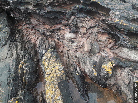
An unconformity is an interface where rock layers meet at an angle (angular unconformity; in a broad sense, a hiatus in parallel strata is also called an unconformity). First, the lower units were deposited shallowly in the sea, then sedimentation stopped, the rocks were folded, lifted above sea level and eroded, and only after a longer period of time were the upper sediments deposited more or less flat on top. In more recent times, erosion by the sea has partially exposed the boundary again. So here you can really see the so-called “cycle of rocks”, an idea that Hutton developed.
The underlying rocks are about 435 million years old (Silurian). They are greywackes and thin layers of mudstone that were deposited in the “primeval Atlantic” Iapetus.
Greywacke is a type of sandstone that contains quartz, feldspar, whole rock fragments and possibly other minerals. It is formed in deep coastal marine basins that are offshore of a mountain range (think of New Zealand or the Andes). The weathered material is first deposited off river mouths and then repeatedly slips into the deep sea as a turbidity current. It is followed by slow, quiet sedimentation of clay particles until the next turbidity current arrives.
Hutton could not yet know why the greywackes were folded, uplifted and eroded; after all, the theory of plate tectonics was not developed until much later (see also my book The Formation of Mountains). The ocean Iapetus closed, the continents Laurentia (today North America and Greenland), Avalonia (a fragment of Gondwana, today England, North Sea, North Germany) and Baltica (today Baltic States and Sweden) collided with each other and the continent Laurussia (also called Old Red Continent) was formed, with the Caledonian Mountains at the seam (today Appalachia, Scotland, Norway, Greenland). The large folds are clearly visible in the escarpment looking east, the steeply dipping strata at Siccar Point are part of a fold limb.
The pause in sedimentation at Siccar Point is 65 million years. The Old Red sandstones above the unconformity were not deposited in the sea (as Hutton believed) 370 million years ago (Late Devonian), but on land in a tropical climate by rivers and partly redistributed by the wind to form dunes. The irregular shape of the unconformity is interesting, e.g. it runs much higher in the cliff above Siccar Point (next to the steep grassy slope). Here we actually see the palaeo-relief, at the time when sedimentation resumed. In the lower areas (the valleys), a conglomerate was initially deposited, the coarse components of which were still derived from the greywackes (a so-called basal conglomerate). Later, only sand was delivered (i.e. derived from an more distant area of the remnants of the Caledonian Mountains), the relief was covered and the sedimentation was relatively flat.
Since then, the whole thing has been slightly tilted and partially exposed again. This long period of time includes the Variscan mountain building (collision of Laurussia and Gondwana and formation of the supercontinent Pangaea), the disintegration of Pangaea with the formation of the Atlantic and finally the Alpine mountain building a little further south (Alps etc.).
James Hutton had actually studied chemistry and medicine, but first worked on his farm to modernise agriculture. The different fertility of soils over different rocks and problems with denudation (soil erosion) led him to study geology. He investigated mines in England and Wales and supervised the construction of the canal between Firth of Forth (near Edinburgh) and Firth of Clyde (near Glasgow). He assumed that present-day geological processes were similar in the past and slowly developed the idea of a cycle of repeated deposition and erosion.
He came across the first unconformity in geological history in 1787 on the Isle of Arran, and found a second one the same year near Jedburgh. The following year he came across Siccar Point. He already had so much experience that he drew the right conclusions. Particularly important was the realisation of the enormous time span shown by this outcrop. The earth history derived from the Bible was no longer tenable. His companion John Playfair later wrote: “The mind seemed to grow giddy by looking so far into the abyss of time”.
Along with Abraham Gottlob Werner, who worked in Freiberg (Germany) at the same time, James Hutton was one of the two “founding fathers” of geology (although mineralogy and mining engineering are much older). Incidentally, Hutton also recognised that granite and basalt are igneous rocks, while Werner considered them to be deposits from a sea — the dispute between “plutonists” and “neptunists” began.
Directions
From Edinburgh, take the A1 eastbound. Just after Cockburnspath, turn left onto the A1107 towards Coldingham. After a narrow bridge, turn left towards Pease Bay. Shortly after, the “main road” to Pease Bay turns left, we go straight on (sign to an agri-business). A little later on the left is the car park for Siccar Point with signs.
Now walk along the coast on a path to the edge of the cliff above Siccar Point. A very steep grassy slope leads down an unpleasantly slippery path, where you can hold on to a fixed rope. You are likely to meet geologists who make a pilgrimage to this spot. Other people rarely stray here, although it is a very pretty place.
Links
- Siccar Point (PDF), James Hutton (PDF) by Lothian and Borders GeoConservation
- The making of an angular unconformity: Hutton’s unconformity at Siccar Point
Read on
Isle of Skye
Eilean Donan Castle
Ben Nevis and neighbouring Munros
Glen Coe
Hike in the Cairngorms
Orkney Islands
At Fingal’s Cave on Staffa