Ben Nevis, the highest mountain in Scotland (and the whole of the UK, I am writing this a week before the independence referendum) attracts many hikers. It’s worth exploring the neighbouring mountains too, where there are quite a few more Munros without the crowds. Munros in Scotland are the mountains above 3000 ft and “munro bagging”, collecting munros, is a kind of popular sport.
There are two approaches for hikers to climb Ben Nevis: via the broad “tourist route” or, which is much more scenic and alpine, via the “CMD route”, the traverse over the neighbouring Munro Càrn Mòr Dearg and further over the crest called Càrn Mòr Dearg Arête; the tourist route then serving as the descent.
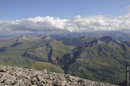
From the campsite in the Glen Nevis valley, I follow the tourist route to a saddle with a small lake, where the main route branches off as a hairpin bend. I continue straight ahead and follow the path, which soon turns into the cirque below the north face of Ben Nevis and leads to a hut. From there I climb pathlessly over grass and gravel up the slope opposite the rock face. The views get better and better, once the cloud cover even lifts enough to see the summit. A good opportunity to also take a look at the geology.
Ben Nevis is part of a caldera that was formed in the Silurian [Update: according to recent research, it was not a caldera; see The Formation of Mountains]. A caldera is a large crater-shaped structure formed when the magma chamber of a volcano empties to the point where there is a collapse of its “roof”. Spectacular examples include Santorini (Greece), Crater Lake (USA), Quilotoa (Ecuador) and the Tengger Caldera (Indonesia). In contrast to these examples, there is nothing to see of the caldera itself on Ben Nevis, instead we are looking at a section through a deeper area. The north wall of Ben Nevis is a block of the “roof” of the magma chamber that has sunk about 600 m into the magma chamber. It consists mainly of grey volcanic rocks: volcanic breccias and ignimbrites deposited by pyroclastic flows in the lower part, andesite lava flows in the upper part. In one place the sedimentary rocks are also exposed, the base below the volcanic rocks. Beneath this subsided block and around it are the rocks of the former magma chamber, called inner and outer granite. The inner granite, which is reddish, also includes the slope I am currently ascending; because of its fine groundmass, I would have rather called the rock “porphyry”. Unfortunately, the contact of the rocks cannot be seen well from a distance, as everything is overgrown with lichen. Incidentally, there is a second caldera not far from here where a slightly higher level is exposed, Glen Coe. There, even at the beginning of the 20th century, it was described in detail for the first time how a caldera is formed. Unfortunately, because of the bad weather, I don’t get to look at it any more …
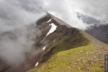
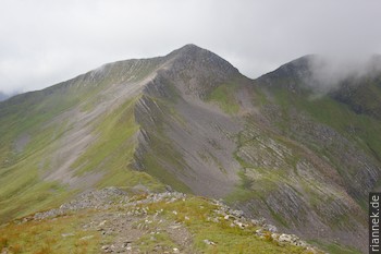
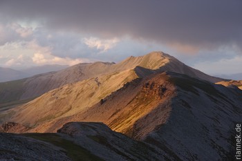
Near the summit of Càrn Dearg Meadhonach, I reach the ridge. Now I continue on a path to Càrn Mòr Dearg and over the adjoining crest, in an arc around the cirque. I take my time, as according to the weather forecast it should clear up in the evening. This actually happens as I climb over boulders to the summit of Ben Nevis. The view, especially of the Marmores to the south, is magnificent. I start my descent so late that I only arrive at the tent at dusk.
I continue with a three-day hike over the neighbouring mountains around the high valley of Glen Nevis, over the Marmores in the south and the Grey Corries in the north (see link above for map). Unfortunately, not exactly in good weather. From the car park at Lower Falls I follow the valley to the SE up to a small lake and further into the saddle. After a detour to the peak Sgùrr a’ Mhàim, I hike from peak to peak of the Marmores: Sgùrr an Iubhair, Am Bodach, Stob Coire a’ Chàirn, Binnein Mòr. Only I’m usually stuck in the thick clouds and once I even have to get out the compass, only in the brief moments with visibility can I guess what I’m missing.
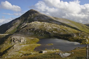
I pass a lake and cross the slope below Sgùrr Eilde Mòr. Now I meander through moors into the valley, where I cross the river near the Luibeilt cottage. The weather is now quite good and I reach the summit of Stob Bàn. Peak after peak I now cross the ridge of the Grey Corries: Stob Choire Claurigh, Stob a’ Choire Lèith, Stob Coire Cath na Sìne, Stob Coire an Laoigh and Sgùrr Choinnich Mòr. Then back down into the Glen Nevis valley. In pouring rain I pass the upper waterfall and the short gorge and reach the road.
As far as geology is concerned, one wanders over the former sediments of the “Ancestral Atlantic” Iapetus. At that time, Scotland was part of the Laurentia continent (North America, Greenland). At it the continental margin, 750 to 500 million years ago, mainly mudstones and sandstones were deposited, occasionally also limestone. The continents on the other side of the ocean, Avalonia (England, Wales) and Baltica (Scandinavia, Baltic States), approached and eventually collided. 430 million years ago (Silurian), the Iapetus Ocean had disappeared, and the collision had pushed up the enormous Caledonian Mountains. The former sediments were transformed and folded into metamorphic rocks: Claystones to shale, sandstones to quartzite and limestone to marble. The hard quartzite stands out because of its white colour, some of the peaks of the Marmores and the Grey Corries are made of it.
Read on
Isle of Skye
Eilean Donan Castle
Glen Coe
Hike in the Cairngorms
Unconformity at Siccar Point
Orkney Islands
At Fingal’s Cave on Staffa
The Formation of Mountains